Please try with this file. I found jpg header FF D8 and deleted every packet before packet with this header
geoscan-mon241122-0954.txt (98.6 KB)
Please try with this file. I found jpg header FF D8 and deleted every packet before packet with this header
geoscan-mon241122-0954.txt (98.6 KB)
I have now been spending a lot of time trying to decode images and haven’t been successful.
We have the following options:
Is there a location where we can find detailed information on frame structure and image recovery?
Any help would be appreciated
@PE0SAT Have you been able to decode image with file from Geoscan-Edelveis mission - #104 by geoscan? Please choose raw jpg when running python script
So all seems to be related on how to manipulate the received output.
python3 ../geoscan-tools/main.py
Input file:geoscan-mon241122-0954.txt
Output file:geoscan-mon241122-0954.jpg
Write raw JPEG (for corrupt/incomplete images, or for multiple files)?y
Characters to remove (16 raw soundmodem, 47 for GetKISS+):16
Single JPEG file only
Wrote raw JPEG!
This is the output:
Hurray! Awesome result. Should we start to transmit photos from space on schedule?![]()
@PE0SAT is there any questions about decoding images left? Apparently script doesn’t crop input file right and if there are some data before FF D8 it tries to parse it and fails.
Please schedule some images and we will try and decode them, if there are questions we know where to find you ![]() @SA2KNG was wondering if it would be possible to use a kiss file for decoding purposes.
@SA2KNG was wondering if it would be possible to use a kiss file for decoding purposes.
This would open up more solutions for decoding. gr_satellites and GetKiss+ can also write kiss files. Follow the link for an example in Index of /download/GEOSCAN
I had a look at the data and came up with this: GitHub - kng/geoscan-tools: Process frames from satellite Geoscan-Edelveis
It tries to capture all data to files, if it detects a proper start and FFD8 header it names it .jpg, otherwise .dat.
Supporting all the formats I have seen in this thread and autodetects how to parse them.
I gave it a try with an earlier observation:
Created a sound modem log file and used the parser created by @SA2KNG
./process_frames.py geoscan-6514407.txt -o geoscan-6514407
This created geoscan-6514407_0.jpg and gives this picture.

And we found another one
My repo is updated with kiss file support and small bug, should produce even partial files with the content in the correct location and the rest padded with 0. so if the transmissions are repeated it might be possible to combine two or more files to one complete ?
Readme updated in my repo.
Added some functionality to combine frames from different transmissions into one file, accumulating data so the images can become complete.
Thanks to the extensive work of @SA2KNG I was able to update my software. Thank you so much!!
As usual, the latest release is here: GitHub - radio-satellites/geoscan-tools: Some tools to process data from the GEOSCAN satellite.
I changed many things:
A future thing that is planned is to combine files that are similar, hence creating an error free file.
Enjoy!
Hi. When is the next transmission of geoscan? What does it transmit? I assume images?
Hi!
Yes, it does transmit images. The GEOSCAN team should release the transmission schedule soon. In the meantime, you can try to figure the software out. Here are your choices (thx PE0SAT):
Photo from a Geoscan flyby a while ago .
New schedule of image transmission (UTC):
28.11.2022 10:12:30
28.11.2022 23:07:00
29.11.2022 09:46:00
29.11.2022 22:42:30
It is still a test. Now it takes a new image before each transmission
Received at 10:10 UTC SatNOGS Network - Observation 6805417
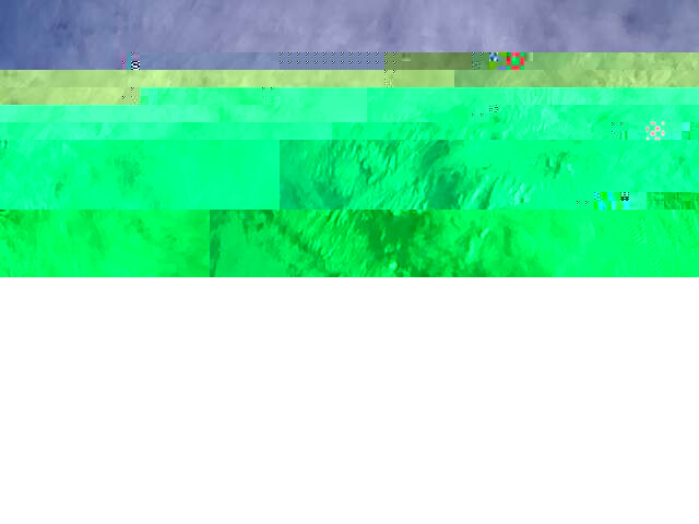
Looks like a good photo. But it seems you lost a packet or few almost at the beginning so it caused this glitch. Satellite should definitely transmit a full image.
Both of these observations have decoded data. Do you think it is possible to reconstruct image with a help from these observations?
https://network.satnogs.org/observations/6805372/
https://network.satnogs.org/observations/6805323/
I believe I have captured the entire transmission except around 26 frames in the beginning where the jpeg header is. I track the satellite manually so it takes a few seconds to get full signal strength after the image transmission starts. Would it be possible to repeat at least the header packets after a transmission ends?
It is possible to transmit an image twice. We will try to do this next time. Maybe you can take these frames from SatNOGS observations. See links mentioned above