Schedule is planned over Europe for upcoming two days. Next will be scheduled for upcoming weekends with transmissions also over North and South America and some part of Asia
8 Likes
Woow thanks for that !!!
1 Like
New schedule!
10.12.2024 scheduled (UTC Time):
Image 1: 15:33:00 + 15:35:00+ 15:37:00+ 15:39:00+15:42:00 (72.6160 W 78.0000 S)
Image 2 17:05:00 + 17:07:00+ 17:09:00+ 17:11:00+ 17:13:00 (11.4160 W, 71.5000 S)
Image 3 18:40:00 + 18:42:00+ 18:44:00+ 18:46:00+ 18:48:00 (170.2367 E, 44.5000 S)
Image 4: 20:13:00 + 20:15:00+ 20:17:00+ 20:19:00 (162.4367 E, 78.5000 S)
11.12.2024 scheduled (UTC Time):
Image 5: 15:08:20 + 15:10:20+ 15:12:20+ 15:14:20+15:16:00 (41.8367 E, 16.5000 S)
Image 6: 16:42:29 + 16:44:30+ 16:46:30+ 16:48:30+ 16:50:30 (174.4367 E, 36.0000 S)
Image 7: 18:17:00 + 18:19:00+ 18:21:00+ 18:23:00+ 18:25:00+ 18:27:00 (170.2367 E, 71.0000 S)
Image 8: 19:48:00 + 19:50:00+ 19:52:00+ 19:54:00+19:56:00 (57.7633 W, 36.5000 S)
7 Likes

This is an incomplete set of packets.
2 Likes


Turn on the “merge mode” in the baskiton decoder and play the *.ogg file several times.
1 Like
Thanks for the guidances! With two kks files (satnogs, self-extracted) and with merge mode. Almost succeeded ![]()
3 Likes
Why is Western Europe always left out? My good pass is at 21:20 UTC when it’s not transmitting anymore, this satellite never transmits over Portugal…

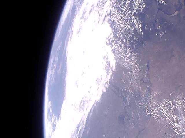
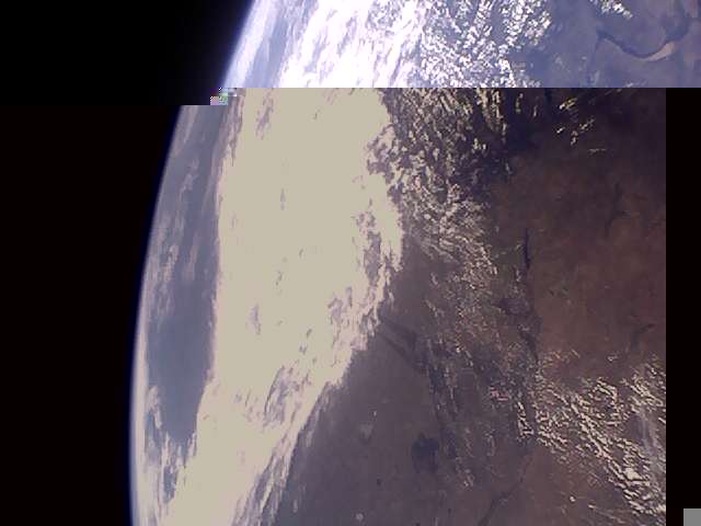
New schedule! Transmission time (and coordinates of taken image)
13.12.2024 scheduled (UTC Time):
Image 1: 06:50:00 + 06:52:00+ 06:54:00+ 06:56:00 (142.8248 W 35.3334 S)
Image 2 08:26:00 + 08:28:00 (11.0537 E, 74.5663 S)
Image 3 10:01:00 + 10:03:00+ 10:05:00 (31.21 E, 121.7447 S)
Image 4: 11:52:00 + 11:54:00 (83.3258 E, 79.7630 S)
Image 5: 14:45:00 + 14:47:00 (125.7707 W, 16.4989 S)
Image 6: 17:35:40 + 17:37:40+ 17:39:00(69.8379 E, 34.1690 S)
Image 7: 19:08:00+ 19:10:00+ 19:12:00+ 19:14:00 (69.8319 E, 34.1690 S)
Image 8: 20:42:00+ 20:44:00(69.8319 E, 34.1690 S)
14.12.2024 scheduled (UTC Time):
Image 9: 12:09:00 + 12:11:00 (31.21 E, 121.7447 S)
Image 10: 11:31:00 + 11:33:00 (162.4367 E, 78.5000 S)
Image 11: 08:05:00 + 08:07:00(170.2367 E, 71.0000 S)
Image 12: 09:40:00 + 09:42:00(57.7633 W, 36.5000 S)
Image 13: 17:32:00 + 17:34:00 (162.4367 E, 78.5000 S)
Image 14: 18:47:00 + 08:59:00(170.2367 E, 71.0000 S)
Image 15: 20:19:00 + 20:21:00+20:23:00 + 20:25:00(57.7633 W, 36.5000 S)
14.12.2024 scheduled (UTC Time):
Image 16: 11:45:00+11:47:00 (41.8367 E, 16.5000 S)
Image 17: 13:20:00 + 13:22:00 (131.7482 W, 29.6062 S)
Image 18: 16:50:00 + 16:52:00+ 16:54:00(38.6689 E, 23.9069 S)
Image 19: 18:25:00 + 18:27:00 (4.4485 W, 43.6044 S)
Image 20: 19:58:00 + 20:00:00+ 20:02:00 (139.9997 E, 66.6639 S)
15.12.2024 scheduled (UTC Time):
Image 21: 00:26:00 + 00:28:00+ 00:30:00 (4.4485 W, 43.6044 S)
Image 22: 00:44:00 + 00:46:00 (139.9997 E, 66.6639 S)
6 Likes
Can I ask how you have all been decoding these images? does anyone have a GSFK sound modem? or are you all using GR satellite?
Here is the GEOSCAN Sound Modem version for Stratosat-TK1
Also have a look at Foxiks decoder on github.
4 Likes
This decoder is better:
4 Likes