RamSat mission progress

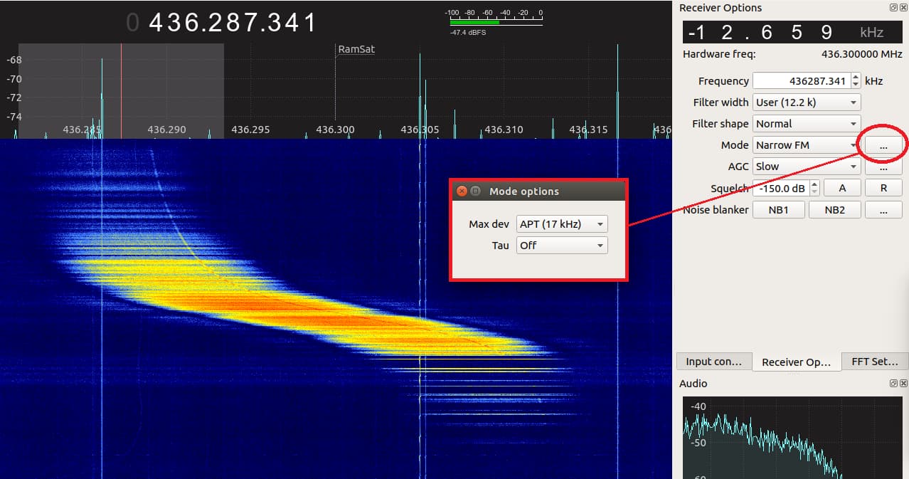
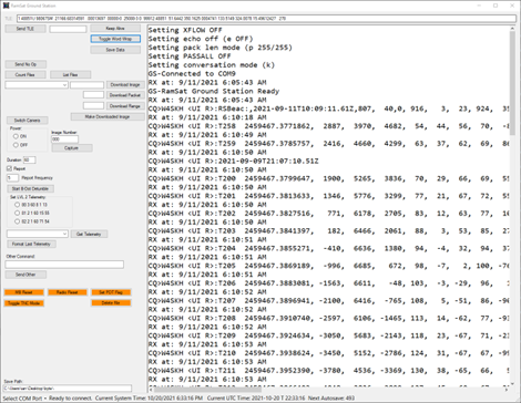
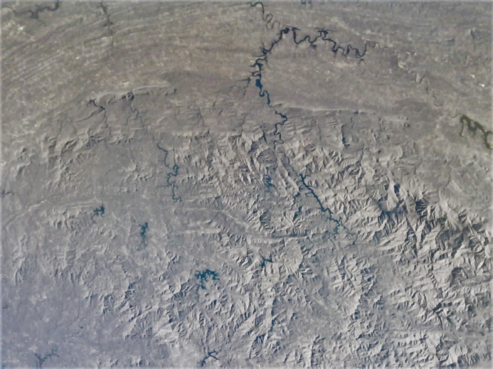
RamSat has just a few weeks left, and we’re continuing to downlink images, taking a few new pictures, and working on repairing jpegs with missing packets. That last part involves a lot of trial and error, but we’re starting to get the knack of it. Here are a few new pictures…


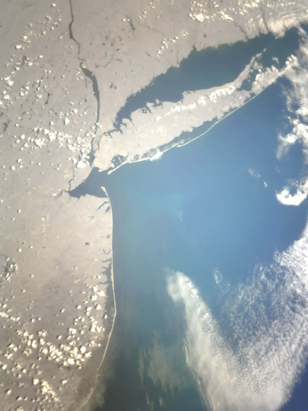
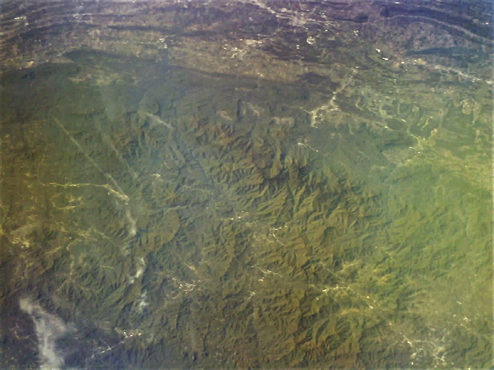
This is a recent favorite, showing all of Long Island with a near-nadir viewing angle, sparse clouds, and good color in the ocean. This is with the visible+NIR camera.

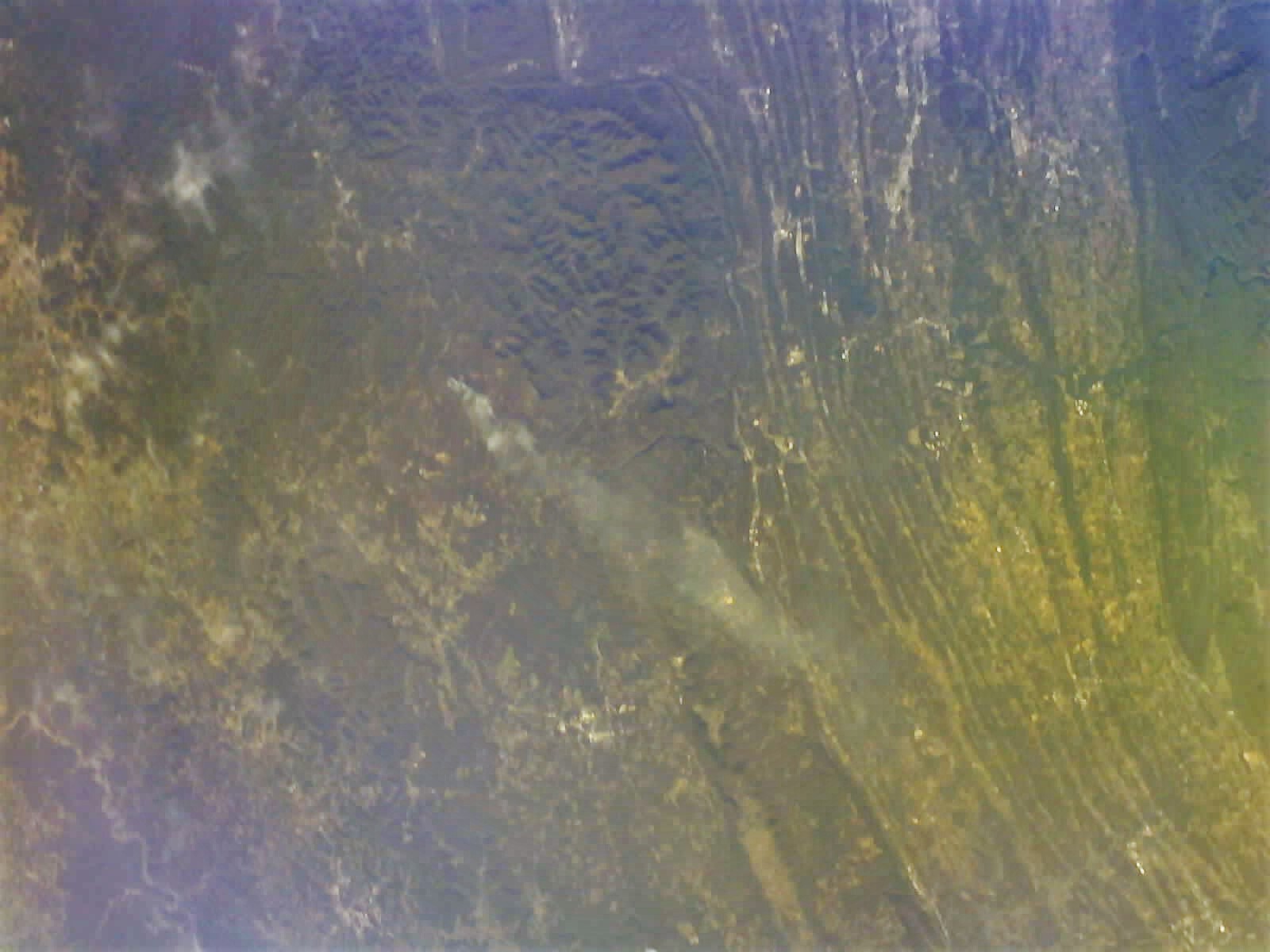
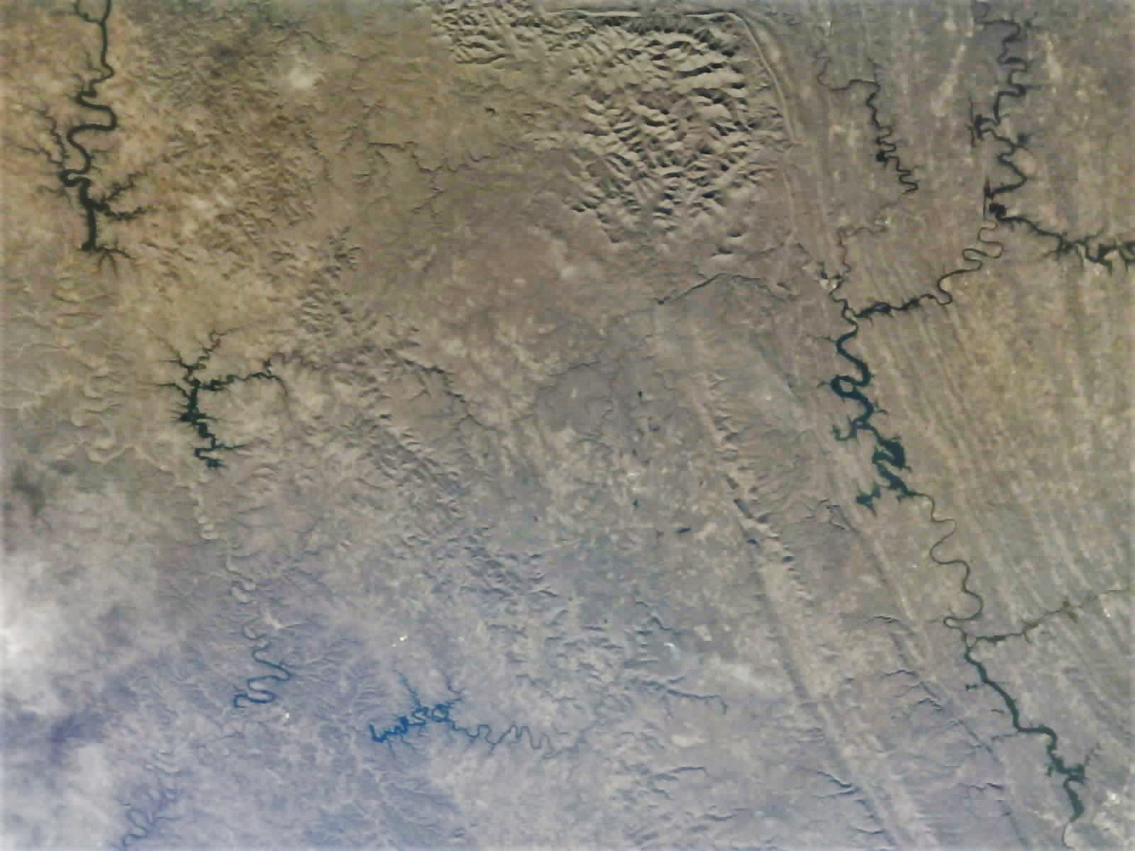
The next two show the results of recent image patching efforts, first the corupt file, then the patched version:


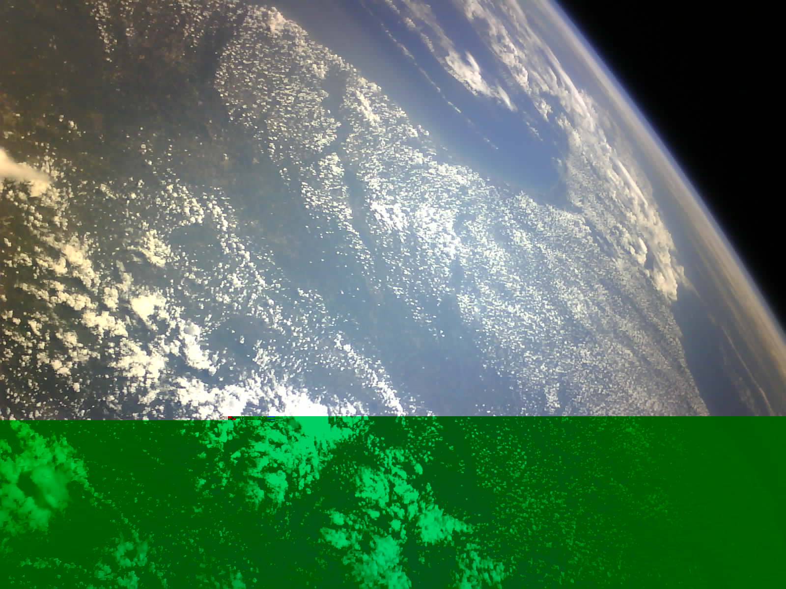
If you look closely at the patched file you can see the artifact from a single missing packet (120 bytes) after repairs. This image is looking down the Florida peninsula, and is taken with the visible+NIR camera. In a previous post I showed the visible-only view from this same capture.

5 Likes

Cool images! Just wondering, what sort of 9600baud packet demodulator do you use? I’m having trouble with direwolf. Also, what software are you using for mission control? Do you have any screenshots? Also, a night-lights NYC picture would be really, really great!

1 Like

Direwolf works well for the 9k6 from RamSat; please be sure that your SDR software is outputting audio bandwidth of at least 15 Khz (such as the ‘17 kHz’ setting in GQRX):

3 Likes

Thank you for your help @K4KDR!! Unfortunately, I made sure that the bandwidth is over 15KHz… here is my direwolf output when running:

Dire Wolf version 1.6

Reading config file direwolf.conf
Available audio input devices for receive (*=selected):
 *  0: Stereo Mix (Realtek(R) Audio)   (channel 0)
    1: Microphone (Realtek(R) Audio)
Available audio output devices for transmit (*=selected):
 *  0: Speakers (Realtek(R) Audio)   (channel 0)
Channel 0: 9600 baud, K9NG/G3RUH, +, 44100 sample rate x 4.
The ratio of audio samples per sec (44100) to data rate in baud (9600) is 4.6
This is on the low side for best performance.  Can you use a higher sample rate?
For example, can you use 48000 rather than 44100?
Note: PTT not configured for channel 0. (Ignore this if using VOX.)
Ready to accept KISS TCP client application 0 on port 8001 ...
Ready to accept AGW client application 0 on port 8000 ...


And then nothing happens.


(In the image the signal is relatively weak compared to what I get in the middle of the pass. I get 45dB+)

Here is my config:

ADEVICE 0
ACHANNELS 1
CHANNEL 0

#Callsign
MYCALL 0000

MODEM 9600

I am running the x86 version. I would appreciate it if you could shed any light on this mystery, as the direwolf support group I go to turned me down and said I’m just doing something wrong.

Thank you!

Our school-based ground station is a Kenwood-TS2000 UHF/VHF transceiver, with Kantronics KPC-9612Plus TNC handling the 9k6 packets. The mission control software is a custom windows application written by @goethert, one of our project mentors. In addition to command and control, that software also manages image assembly once all image data packets have been downlinked. Here is a screenshot of the ground station software.
image

2 Likes

You may wish to use the following in your .CONF file for Direwolf:

ARATE 48000
MODEM 9600 0:0

… and also, I can’t tell but verify that the output from your SDR software is also at a sample rate of 48000.

It’s also EXTREMELY helpful to use a virtual audio device to connect SDR software & other apps such as Direwolf. On windows, I’ve had good luck with

Hope that helps!

@K4KDR Again thank you very much for your help!

Unfortunately, I did verify the output of SDR++ was 48000, I even set it to 192000 but still it doesn’t work :frowning:

My config is now:

ADEVICE 0
ACHANNELS 1
CHANNEL 0
ARATE 48000

#Callsign
MYCALL 0000

MODEM 9600 0:0

I’m going to try to reinstall direwolf, if not, I’ll try SoundModem. If not, I’ll try to get gqrx (which appears to be the software you’re running). EDIT: Haha gqrx doesn’t run on windows :slight_smile:

Thank you!! :slight_smile:

But are you using the virtual audio cable? You should feed the demodulated audio from SDR to this cable and connect to it with direwolf, otherwise you just feeding it to the headphones and no signal is getting to direwolf.

As intermediate test, you can use for example Audacity, and it should be able to record the audio from SDR, using virtual audio cable output. You should see there the packets. Playing then the recording into VAC, properly set direwolf should decode them again.

Thank you for your help @ok2pnq and @K4KDR !!! I got it working now with SoundModem and virtual audio cable!!! Thank you!

@pethornton I noticed the last few packets were

1:Fm CQ To W4SKH <UI R Pid=F0 Len=54> [16:18:52R] [AA] [+++++++]
RamSat: Packet received, entering command interpreter.
1:Fm CQ To W4SKH <UI R Pid=F0 Len=71> [16:18:53R] [AA] [+++++++]
RamSatSP: CMD2_604.JPG is open to read packet: Size=63496: npackets=530

However, no image dump was received after that, and according to gpredict the satellite was -3 degrees below your horizon?!?!

2 Likes

@jupitersaturn09 I’m not sure which pass these decoded packets are from, but it looks like it could be from around 19:34 UTC on 22 September. This would have been toward the end of the pass, and it was probably the last command received by RamSat as it was dropping out of range. You can see decodes from the end of that pass here: SatNOGS Network - Observation 6512404
In the last command we are asking for a single packet from file CMD2_604.JPG, although RamSat’s echo of those single-packet requests don’t show which packet was requested. The response is to return packet 251. That was followed by a telemetry beacon.
Sometimes we will be able to send an image dump or a detumble detumble command right at the end of the pass, which may execute for one or more minutes after RamSat has passed out of range. The output from executing those commands is often recorded by down-range stations, and we look for the data in the SatNOGs database to fill in our own received data. One of the many benefits our mission receives from this amazing community!

4 Likes

A quick note of thanks for all the observers who are helping us track the last days in orbit for RamSat. We have had a very successful final few days of image downlink, and I’ll share results here soon. Now we are just hoping to catch as much telemetry data as possible during the final few orbits. Elevation is just below 200km, mean motion is about 16.2 orbits per day. The end is very near. So far no clear signs of heating.

3 Likes

@usugasteam your latest observation shows RamSat still alive and well over North America! If we last until 18:21 UTC today I’ll try to send out a thank you message to our sponsors on the last likely pass over our ground stations in east Tennessee. The message was programed before launch, so it will not acknowledge SatNOGs, but know that it is going out to you all as much as any of our financial sponsors.

Update: J C got a beacon at station 1486, and @vi3wroy4l also got a beacon on orbit 7558 over North America, at station 1775. Thanks!

6 Likes

Latest beacon from east coast USA as well from at 16:51:36 UTC 1675

2022-10-10T16:51:36.70Z,827, 98,1, 981, 98, 10, 982, 13, 172, 496, 8, 827, 190,827, 10,333, 42,504, 64, 139, 145, 157, 256, 217, 226, 202, 0, 28, 31, 24, 70, 104, 2, 12, 33083, -8168, 21998,0000, -7922, 4900,1980

:satellite:

3 Likes

Congrats to everyone on the RAMSAT team - just a great mission from start to finish.

https://twitter.com/scott23192/status/1579542296915156993

3 Likes

Latest/last beacon verified at two stations 2022-10-10T18:24:48.30Z

2022-10-10T18:24:48.30Z (Station 1675)

2022-10-10T18:24:48.30Z (Station 1539)

®h¦–@`†¢@@@@áðRSBeac:,2022-10-10T18:24:48.30Z,825, 272,1, 893, 59, 10, 911, 192, 13, 474, 7, 827, 393,825, 3,334, 42,505, 57, 143, 145, 157, 251, 217, 226, 192, 0, 4, 19, 12, 0, 19, 59, 67, -7433, 19013, 30143,0000, -7607, 3804,1946

:satellite:

3 Likes

It was a flurry of activity on our likely last pass, starting today (10 October 2022) around 18:20 UTC. We wanted to get the latest TLE uplinked, and update the real-time clock, so that location and elevation information in downlinked telemetry would be as accurate as possible for remaining orbits. That was successful. Then since we had managed to downlink all the images onboard we tried for one more image pair (CMD1_903.JPG and CMD2_903.JPG). The file sizes for these images indicate that they are likely good images of the Earth, as opposed to pointing out in space. We then started a downlink of CMD1_903.JPG, hoping that between our station and the network observations we might get at least a partial image. There was a weird glitch that stopped the image access from onboard SD card prematurely, and we were then able to resend the downlink command. It looks like it got past the previous glitchy spot, but was out of range long before we saw the last packets. We were able to receive packets down to about 1.5 degrees above horizon, so a nice last pass! When @N1ESK is back online he will pull together network obs and we’ll see what we came up with on our last shot.

2 Likes

Due to the imaging action, we didn’t send the “thank you” command on this last pass. Better to try for more data, we thought!
However, I promised some imagery results, and now that many on our team have had a chance to see the lates, I’m glad to share them with you all. It is difficult to describe exactly how lucky we got on these last images, but I’ll try - bear with me. This past Wednesday we were working an early evening pass (17:00 local time, approximately). We had gotten all of the images stored on RamSat that looked promising based on file size, and it was a nice clear day with an almost direct overhead pass. @N1ESK suggested we try a couple more images, knowing that the chances of a good image in any given session are low, and knowing that we were very nearly out of time to work the downlink passes. We fired off one image as RamSat was directly overhead, then another immediately afterwards as it was slightly down-range to the East. These were image pairs 901 and 902 for those of you keeping track at home. The file sizes were unusually large, which is a good sign that we’re seeing something on the ground. We began to downlink on the next pass. We worked every pass above about 15 degrees on Thursday, Friday, and through the weekend, up until the 8am local time pass today. We managed to get complete images for both pairs (visible and NIR cameras for image 901 and 902), thanks in no small part to the many SatNOGs ears that were listening and helping us fill in the packets we were missing at our two RamSat ground stations.

The project mission, which the middle school classes 2016 and 2017 came up with, was to study the area around Gatlinburg, Tennessee, where a severe wildfire in October 2016 had burned a large area of forest, destroying many homes and buildings, and causing significant loss of life. So we’ve been trying since June 2021 to get good images over that area. We had partial success this past spring, with a single pair of images that was looking at the area from a distant angle. Better than nothing, but not very clear. We had also been hoping from the outset to get an image over our home in Oak Ridge, Tennessee. the image from the spring gave us that as well, but just barely.

I’m pasting below the images gathered literally at the last moments of our mission. One pair captures a beautiful view of Oak ridge, and the Cumberland Plateau which sits to the West, between us and Nashville. The first image is the visible camera, then the NIR camera, and then a google Earth view for context…

5 Likes

I manged to get some very good observations over the past few days when the sat passes overhead and tomorrow should be another good day, hopefully my data is useful and reaching you :slightly_smiling_face:


4 Likes

The next pair of images is the 902 pair, and in that pair we managed to capture the Smoky Mountains, the town of Gatlinburg, the area burned by the fire, and a lot of other interesting features, including Knowxville, our aiport, and on and on… Same as before, visible, then NIR, then a google earth map:

RamSat happened to be rotating around its Z-axis (still is), and if not for that the second shot would have missed the Smoky Mountains. We are so very thankful for all the help from SatNOGs in capturing these images.

3 Likes