KSLV-2 - CAS500-3 Mission - 2025-11-26 16:13 UTC

First STRF checks:

K-HERO seems to be active on 437.180 and not 437.165

K-HERO
1 98489U          25331.07818638  .00000000  00000-0  50000-4 0    05
2 98489  97.7900 258.8600 0000717   0.0000 125.9397 14.92727873    02
# 20251127.01-20251127.08, 34 measurements, 0.072 kHz rms
4 Likes

SNUGLITE-III beacon structure [2025.11.26] SNUGLITE-III Beacon Structure | SNU GNSS Laboratory

Jan | PE0SAT

3 Likes

Two JACK satellites on the same frequency, I need separation to create better TLE

Jan | PE0SAT

2 Likes

SNUGLITE-III HANA

The signals aren’t very strong over Europe

SNUGLITE-III HANA
1 98496U          25331.53333537  .00000000  00000-0  50000-4 0    04
2 98496  97.7900 258.8556 0000717   0.0000  51.0993 14.95170608    02
# 20251127.47-20251127.53, 12 measurements, 0.139 kHz rms

Jan | PE0SAT

4 Likes

SPIRONE

SPIRONE
1 98492U          25331.53369996  .00000000  00000-0  50000-4 0    08
2 98492  97.7900 258.9891 0000717   0.0000  50.9212 14.91953691    00
# 20251127.47-20251127.53, 21 measurements, 0.149 kHz rms
4 Likes

SNUGLITE-III DURI

Very weak on 436.788

Jan | PE0SAT

4 Likes

INHA-ROSAT

INHA-ROSAT
1 98490U          25331.53393606  .00000000  00000-0  50000-4 0    01
2 98490  97.7900 259.2495 0000717   0.0000  50.8313 14.89340176    08
# 20251127.53-20251127.54, 12 measurements, 0.072 kHz rms

Jan | PE0SAT

4 Likes

Thanks all TLE updates Jan. Here is INHA-RoSAT sending 9K6 GMSK 1836Z FN41iq 42W

4 Likes

First of all, thank you all.

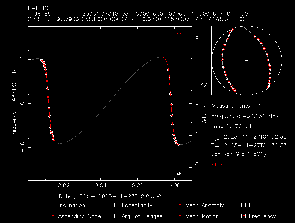
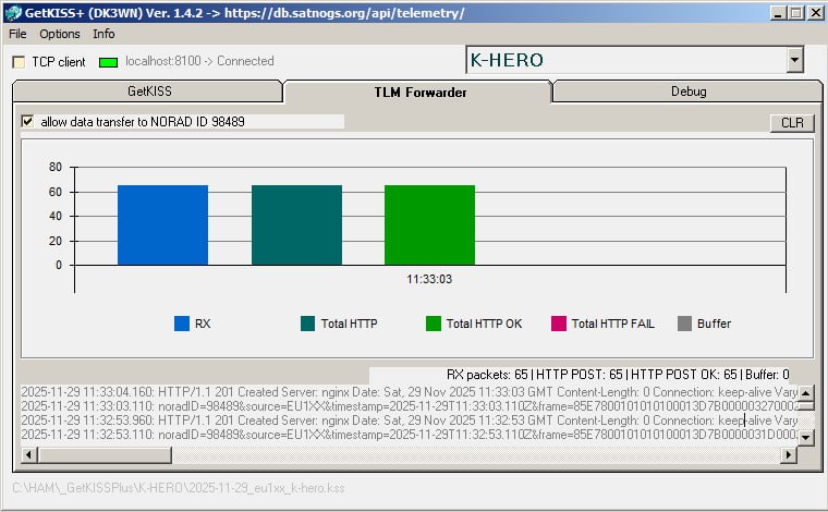
I’m managing the K-HERO mission right now, and SatNOGS’ network observation greatly improved our initial orbit operation.
It looks like the UPDATED TLE’s altitude shows approximately 590 km, whereas based on K-HERO GPS data (included in beacon), it is approximately 588.3 km. It looks like the altitude is different from what I’ve noticed from the launcher side (~ 600 km).

@PE0SAT Which method did you use to update TLE, is it based on RF signal observation data?

Best,

3 Likes

Welcome on the channel, it always great to see mission members.

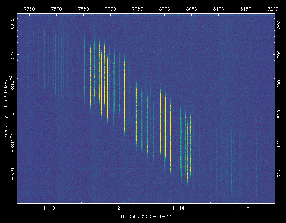
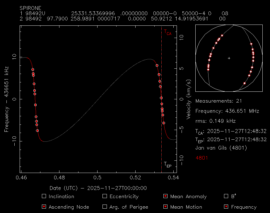
We use STRF for Doppler measurements and create TLE from those,
Ideally we would use multiple passes and then fine tune the TLE, in this case where there was nothing publicly available we used Epoch, Inclination, orbit and launch location.

I had a look at https://www.space-track.org/ but there is nothing available yet so we will try to update the current ones.

If you can share more details on its orbit, state vectors or preliminary TLE please do.

Jan | PE0SAT

STRF Crash course

2 Likes

JACK-003 and 004 are already drifting apart

We could try and get some TLE

Jan | PE0SAT

4 Likes

Hello,
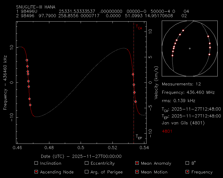
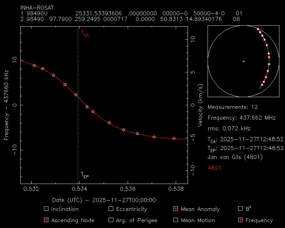
I am in charge of communications for INHA RoSAT.
Thanks to your support, we are successfully monitoring the status of our satellite. We sincerely appreciate your help.

Based on the received GPS data, we reconstructed an updated TLE. We are currently observing about a 2-minute difference compared to the SatNOGS-predicted pass, and we have confirmed signal reception that matches our updated estimation.

We would appreciate it if you could reflect this new TLE.

INHA RoSAT
1 99999U 1800100  25331.80246389  .00000000  00000-0  25992-3 0  9999
2 99999  97.7444 259.2713 0001305 357.3743  54.4032 14.91727050    17

Thank you again for your support.

3 Likes

The TLE changed to use the temporary NORAD ID we use in DB:

INHA RoSAT
1 98490U          25331.80246389  .00000000  00000-0  25992-3 0  9994
2 98490  97.7444 259.2713 0001305 357.3743  54.4032 14.91727050    12
2 Likes

@fredy Thank you for updating the TLE.

Thanks to your support, we have been able to continuously confirm that the signal is being received properly.

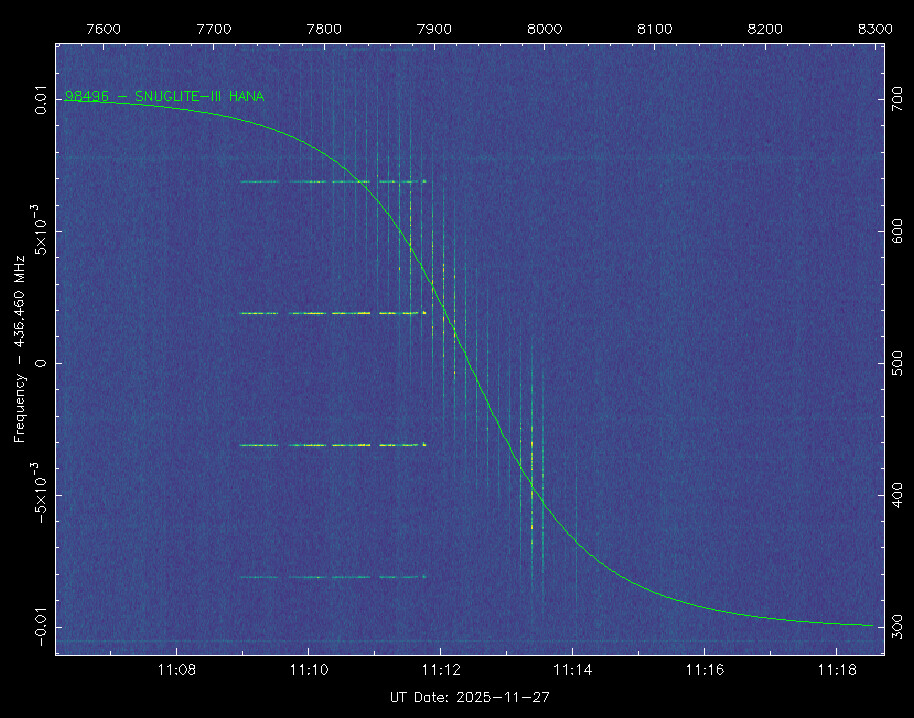
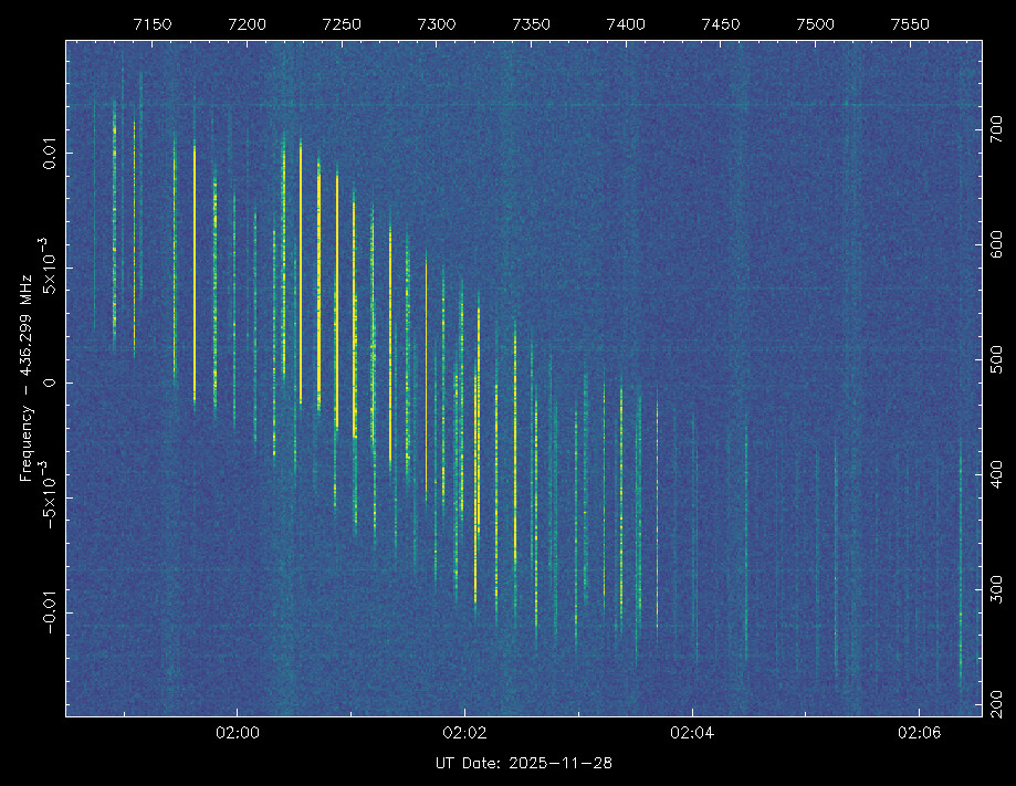
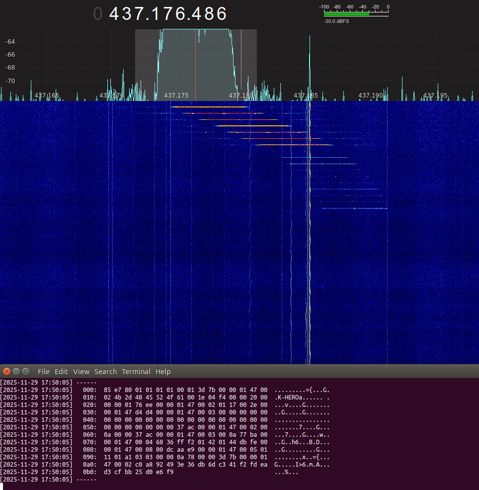
For those attempting to receive our satellite’s signal, we would like to share some additional information about INHA RoSAT.
To reduce power consumption, the satellite is currently transmitting only the Audio Beacon.
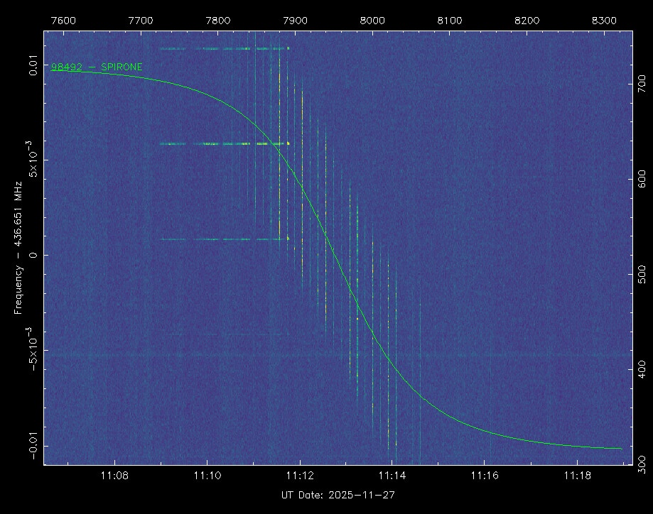
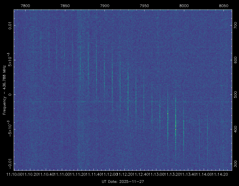
As shown in the waterfall, the Audio Beacon is visible when transmitted, and it is emitted every 5 minutes.

We would like to once again express our sincere gratitude to everyone who has been receiving and tracking our signal. Thank you!

3 Likes

@jociiiii Thank you for the info!

I may suggest, if possible, you change the interval to 3min, this way we can have 2 to 3 points in each pass that can help us identify the satellite.

By the way we have assigned TLE from space-track for this launch for all the expected objects, so we can start the identification process.

0 OBJECT A
1 66650U 25274A   25333.20177411  .00001671  00000-0  17204-3 0  9994
2 66650  97.7378 260.6402 0010697 303.2303  56.7890 14.91585531   381
0 OBJECT B
1 66651U 25274B   25333.20168531  .00002593  00000-0  26341-3 0  9994
2 66651  97.7366 260.6400 0011042 302.4766  57.5384 14.91639250   381
0 OBJECT C
1 66652U 25274C   25332.32945814  .00001430  00000-0  14724-3 0  9995
2 66652  97.7376 259.7852 0010856 312.4916  47.5385 14.91788681   252
0 OBJECT D
1 66653U 25274D   25332.26221872  .00001418  00000-0  14521-3 0  9991
2 66653  97.7326 259.7196 0009575 324.7926  35.2659 14.92039319   247
0 OBJECT E
1 66654U 25274E   25331.52445602  .00001313  00000-0  13508-3 0  9997
2 66654  97.7383 258.9963 0012320 312.3234  47.6940 14.91950445   130
0 OBJECT F
1 66655U 25274F   25333.13407584  .00003040  00000-0  30538-3 0  9995
2 66655  97.7373 260.5753 0012201 306.4109  53.5984 14.91960566   374
0 OBJECT G
1 66656U 25274G   25333.20084307  .00003290  00000-0  32848-3 0  9991
2 66656  97.7369 260.6413 0012879 307.5870  52.4178 14.92139275   382
0 OBJECT H
1 66657U 25274H   25333.20055544  .00003244  00000-0  32263-3 0  9993
2 66657  97.7367 260.6418 0011580 326.2866  33.7616 14.92319714   384
0 OBJECT J
1 66658U 25274J   25333.20025741  .00002996  00000-0  29701-3 0  9996
2 66658  97.7368 260.6423 0012188 328.8358  31.2137 14.92496768   387
0 OBJECT K
1 66659U 25274K   25333.19994443  .00003154  00000-0  31089-3 0  9998
2 66659  97.7370 260.6425 0012947 329.8933  30.1541 14.92682495   387
0 OBJECT L
1 66660U 25274L   25333.19969424  .00003711  00000-0  36335-3 0  9999
2 66660  97.7370 260.6431 0013565 330.1871  29.8574 14.92831648   386
0 OBJECT M
1 66661U 25274M   25333.19942728  .00002576  00000-0  25295-3 0  9999
2 66661  97.7370 260.6434 0014219 330.9976  29.0452 14.92987976   384
0 OBJECT N
1 66662U 25274N   25333.19930421  .00001590  00000-0  15795-3 0  9996
2 66662  97.7378 260.6434 0014611 330.6795  29.3604 14.93058196   381
0 KSLV-II R/B
1 66663U 25274P   25332.25598398  .00001870  00000-0  16348-3 0  9992
2 66663  97.7400 259.7351 0045467   6.3451 353.8337 14.97233772   246
4 Likes

K-HERO is suitable object 66660 (2025-274-L) now

5 Likes

Thanks for providing detailed information.

Below is the state vector of K-HERO which I received from launcher.

Lift Off Time: 2025/11/26 16:12:59.915 (UTC)

SAT Separation Time: 2025/11/26 16:27:35.475 (UTC)

Mission Elapsed Time: 875.56 s — From lift-off to separation

Position (ECEF Coordinates):

• X Position: −4060.7639 km

• Y Position: 5672.6250 km

• Z Position: 174.8205 km

Velocity (ECEF Coordinates):

• X Velocity: 1132.475 m/s

• Y Velocity: 1043.993 m/s

• Z Velocity: −7484.112 m/s

Attitude (321 Euler Angles w.r.t LVLH Coordinates):

• X Attitude: −89.46 deg

• Y Attitude: 36.48 deg

• Z Attitude: −173.82 deg

Angular Rate (Body-Fixed Coordinates):

• X Angular Rate: 0.25 deg/s

• Y Angular Rate: 0.08 deg/s

• Z Angular Rate: 0.47 deg/s

Hope this data helps.

Best,

2 Likes

FYI, K-HERO sometimes fell into safe (low power) mode, which turned off the auto beacon. My team is currently working on this matter. :shaking_face:
SatNOGS’ observations greatly helps!!!

4 Likes

K-HERO frames on 10-sec interval over the Eastern U.S. 1750utc 29-Nov

4 Likes

SPIRONE is suitable object 66657 (2025-274-H) now

3 Likes