Thank you for the submission! I’ll take a look ![]() Every file helps me make the script better
Every file helps me make the script better
2 Likes
Is there any progress in improving the program ?
Any news from X- Band ? ![]()
For those that run this script on Unix and run into the following error:
/geoscan_proc.py
./geoscan_proc.py: line 1: import: command not found
from: too many arguments
./geoscan_proc.py: line 3: ImageFile.LOAD_TRUNCATED_IMAGES: command not found
./geoscan_proc.py: line 4: $'\r': command not found
./geoscan_proc.py: line 5: import: command not found
./geoscan_proc.py: line 6: import: command not found
./geoscan_proc.py: line 10: $'\r': command not found
./geoscan_proc.py: line 11: syntax error near unexpected token `('
'/geoscan_proc.py: line 11: `in_file = input("Input file:")
This script seems to be created on a non Unix system and has ^M entries in the file that are responsible for this error. With the command dos2unix geoscan_proc.py you can convert the file.
Good luck.
4 Likes
Hello everyone, we have few updates considering our mission.
- We and MIREA (our supporting university in terms of Amateur-Radio Satellite Service) have coordinated frequencies with IARU! Page on AMSAT UK website will be updated soon!
- We have updated our Telemetry Beacon. Now it have AX.25 format (without 5 bytes prefix as it was earlier). Also we have put much more information in it about our cubesat.
- We have created merge request in satnogs-decoders with our satellite’s beacon decoder
- We are still testing our X-band transmitter. Apparently it is working but we could not receive any signal from it on our antenna. It is still in test mode and transmitting only on command.
- Satellite will start to transmit images over Europe, America and Japan after its status will be changed. So much more people will be able to receive images.
7 Likes
We are officially coordinated our frequencies.
http://www.amsatuk.me.uk/iaru/finished_detail.php?serialnum=873
7 Likes
Fantastic job! I assume the images are downlinked on command? Who is the person in charge of that in North America?
I’m working on an experimental version of the software for GEOSCAN that can parse the date and time from the packets. However, it probably won’t be up until about December due to exams and midterms in my school.
Just keeping everyone in the loop =D
3 Likes
We can transmit images on time also. We will post schedule of images transmission here everytime image beacon will be on.
3 Likes
Keep up with great job! If would need some help with it, feel free to pm me on SatNOGS!
Thank you
3 Likes
2 Likes
yes I think this is right. Working on multiple-file extraction
Hey @geoscan do you know how are the image files separated when they are transmitted? I have an idea but I’m not really sure right now
EDIT:
After extensive reversing, I find that the header transmitted by GEOSCAN before each image is
4F 4F 4F 4F 4F 4F 4F 4F 4F 4F 4F 4F 4F 4F 4F 4F 4F 4F 4F 4F 4F 4F 4F 4F FF C4 01 A2 00 00 01 05
I think I can make this work.
2 Likes
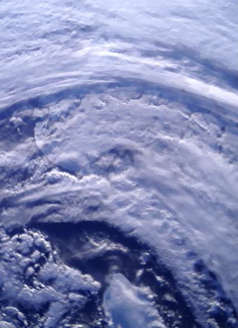
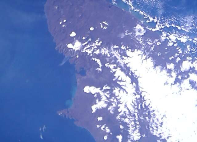
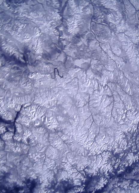
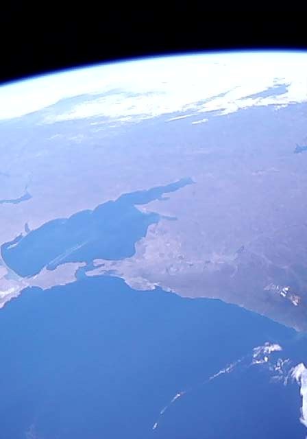
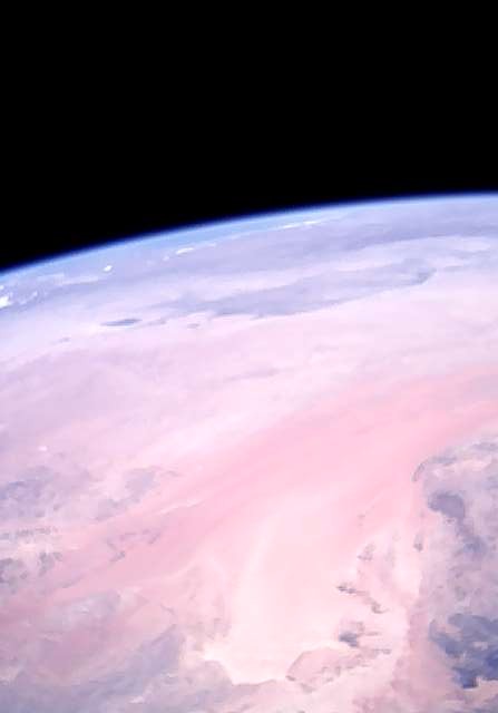
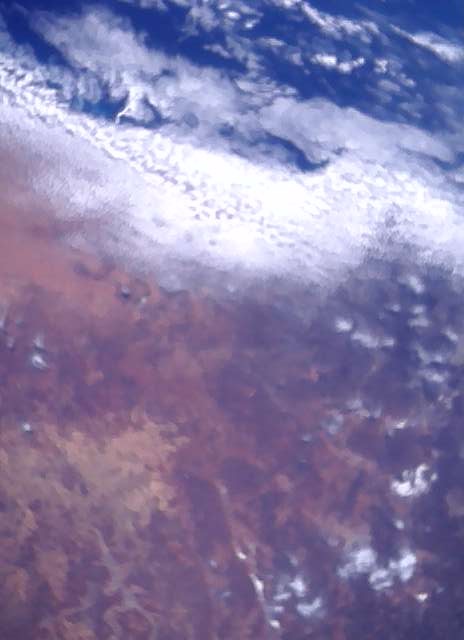
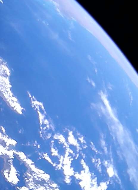
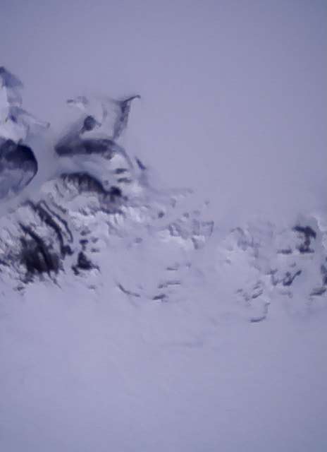
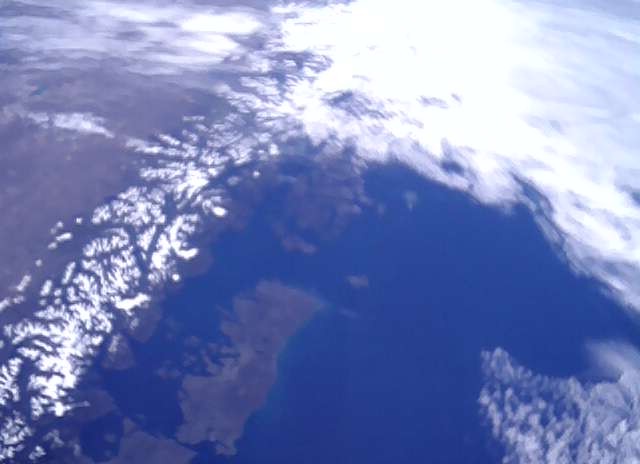
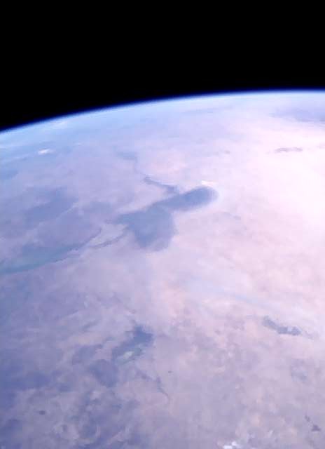
Before Geoscan-Edelveis will transmit images we wanted to share with you images it made these months. Here are the best of them
Laptev Sea
Kamchatka
Magadan Oblast’, Russia
Black Sea
Arabian Peninsula
South Australia
Australia and Indonesia
Antarctica and McMurdo Station
Andes
Niger, Nigeria, Chad, Cameroun
5 Likes
In an effort to make the newest version available, I have uploaded a beta version in the github (GitHub - radio-satellites/geoscan-tools: Some tools to process data from the GEOSCAN satellite.). The biggest change is a massive code cleanup, and basic multiple-file support (no decoding, though). I am communicating with the team on that note (thanks geoscan!!).
When processing with multiple files, it is necessary to NOT enter an output file name at first - it will be asked when multiple files are detected.
3 Likes
hmm… could it be possible to take an image every 30 seconds for whole-orbit coverage? Just an interesting idea…
Thanks for the effort and development.
After running the program I have 33 output files, in what way can I try to convert them to an image?
Input file:Geoscan.txt
Output file:
Write raw JPEG (for corrupt/incomplete images)?y
Characters to remove (16 raw soundmodem, 47 for GetKISS+):16
Detected multiple files downlinked...
33 files have been detected
outfile: my
Processed 1 out of 33
Processed 2 out of 33
Processed 3 out of 33
Processed 4 out of 33
Processed 5 out of 33
Processed 6 out of 33
Processed 7 out of 33
Processed 8 out of 33
Processed 9 out of 33
Processed 10 out of 33
Processed 11 out of 33
Processed 12 out of 33
Processed 13 out of 33
Processed 14 out of 33
Processed 15 out of 33
Processed 16 out of 33
Processed 17 out of 33
Processed 18 out of 33
Processed 19 out of 33
Processed 20 out of 33
Processed 21 out of 33
Processed 22 out of 33
Processed 23 out of 33
Processed 24 out of 33
Processed 25 out of 33
Processed 26 out of 33
Processed 27 out of 33
Processed 28 out of 33
Processed 29 out of 33
Processed 30 out of 33
Processed 31 out of 33
Processed 32 out of 33
Processed 33 out of 33
2 Likes
@geoscan mentioned that he will release the format shortly in a PM. Until then, I can’t do anything, only output binary files which is what the program is doing. I can add a feature to attempt to make images (based on some guessing), but otherwise I can’t do much here.
Thank you so much for using my program!! It means a lot to me ![]()
EDIT: done
The correct usage will be (for you):
Input file:Geoscan.txt
Output file:
Write raw JPEG (for corrupt/incomplete images, or for multiple files)?n
Characters to remove (16 raw soundmodem, 47 for GetKISS+):16
Detected multiple files downlinked...
Process the images into JPEG (and binary)?y
33 files have been detected
outfile: my
By the way, is it possible to send the file? Just to look for more patterns =D
2 Likes
Can I use the mail address found on qrz.com?
The example you shared is what I used to create the files.
But looking at the files, I can use them again because they are all striped of the soundmodem and GetKISS+ data.
python3 ../geoscan-tools/main.py
Input file:Geoscan.txt
Output file:
Write raw JPEG (for corrupt/incomplete images, or for multiple files)?y
Characters to remove (16 raw soundmodem, 47 for GetKISS+):16
Detected multiple files downlinked...
Process the images into JPEG (and binary)?y
33 files have been detected
outfile: my
This is not an image.
Processed 1 out of 33
This is not an image.
Processed 2 out of 33
This is not an image.
Processed 3 out of 33
This is not an image.
Processed 4 out of 33
This is not an image.
Processed 5 out of 33
This is not an image.
Processed 6 out of 33
This is not an image.
Processed 7 out of 33
This is not an image.
Processed 8 out of 33
This is not an image.
Processed 9 out of 33
This is not an image.
Processed 10 out of 33
This is not an image.
Processed 11 out of 33
This is not an image.
Processed 12 out of 33
This is not an image.
Processed 13 out of 33
This is not an image.
Processed 14 out of 33
This is not an image.
Processed 15 out of 33
This is not an image.
Processed 16 out of 33
This is not an image.
Processed 17 out of 33
This is not an image.
Processed 18 out of 33
This is not an image.
Processed 19 out of 33
This is not an image.
Processed 20 out of 33
This is not an image.
Processed 21 out of 33
This is not an image.
Processed 22 out of 33
This is not an image.
Processed 23 out of 33
This is not an image.
Processed 24 out of 33
This is not an image.
Processed 25 out of 33
This is not an image.
Processed 26 out of 33
This is not an image.
Processed 27 out of 33
This is not an image.
Processed 28 out of 33
This is not an image.
Processed 29 out of 33
This is not an image.
Processed 30 out of 33
This is not an image.
Processed 31 out of 33
This is not an image.
Processed 32 out of 33
This is not an image.
Processed 33 out of 33
The output shows
Geoscan.txt  my13.jpg  my17.txt  my21.jpg  my25.txt  my2.jpg   my3.txt  my8.jpg
my0.jpg      my13.txt  my18.jpg  my21.txt  my26.jpg  my2.txt   my4.jpg  my8.txt
my0.txt      my14.jpg  my18.txt  my22.jpg  my26.txt  my30.jpg  my4.txt  my9.jpg
my10.jpg     my14.txt  my19.jpg  my22.txt  my27.jpg  my30.txt  my5.jpg  my9.txt
my10.txt     my15.jpg  my19.txt  my23.jpg  my27.txt  my31.jpg  my5.txt
my11.jpg     my15.txt  my1.jpg   my23.txt  my28.jpg  my31.txt  my6.jpg
my11.txt     my16.jpg  my1.txt   my24.jpg  my28.txt  my32.jpg  my6.txt
my12.jpg     my16.txt  my20.jpg  my24.txt  my29.jpg  my32.txt  my7.jpg
my12.txt     my17.jpg  my20.txt  my25.jpg  my29.txt  my3.jpg   my7.txt
And all jpg files are empty
I have made the Geoscan.txt file available via this link
wow this is unlike anything I’ve seen before! The amount of zeros…