fredy
January 20, 2023, 5:47pm
1
Here is a TLE set until we have any updated one from space-track.org . Given that the signal is wide and the process pretty manual don’t expect pretty accurate results:
FALCONSAT 3
1 30776U          23020.50000000  .00000000  00000-0  15010-2 0    07
2 30776  35.4172 249.6429 0008773   6.7873  79.9314 16.26858001    09
3 Likes
@fredy Thanks for this. Falconsat 3 is still alive and well. Good signal and decodes from a low elevation pass (< 12 deg) at 19:20 UTC
obs 7058708 and 7058710
2 Likes
fredy
January 21, 2023, 12:27am
3
One more update… still not perfect accuracy but better fit than the previous TLE set:
FALCONSAT-3
1 30776U          23020.90000000  .00000000  00000-0  15010-2 0    01
2 30776  35.4172 244.8769 0008773 240.9884  36.8341 16.30056322    00
fal3-3.dat (6.2 KB)sites.txt (1.8 KB)
2 Likes
yd9ckh
January 21, 2023, 1:04am
4
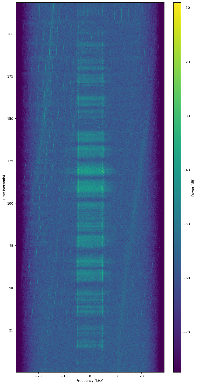
it look doppler moving to fast…
kerel
January 21, 2023, 3:41am
5
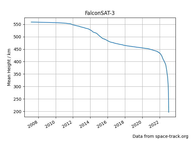
To get a better sense of the history of FalconSAT-3 I just plotted the mean orbital height using historic orbit data from space-track:
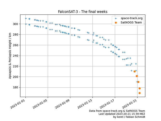
And a second plot limited to 2023 and including the two TLEs calculated by fredy:
(edits [13:00Z, 13:43Z]: Plot updated with latest data points)
Let’s hope that FalconSAT-3 stays long enough in orbit to get one or two additional points on this plot.
4 Likes
fredy
January 21, 2023, 11:21am
6
One more attempt that is not again very good:
FALCONSAT-3
1 30776U          23021.20000000  .00000000  00000-0  15010-2 0    05
2 30776  35.4172 240.8266 0008773  65.1668 181.0154 16.34265715    02
fredy
January 21, 2023, 12:14pm
7
One more
FALCONSAT-3
1 30776U          23021.40000000  .00000000  00000-0  40332-2 0    02
2 30776  35.4172 243.8637 0008873  14.0801 328.9778 16.38800300    03
1 Like
fredy
January 21, 2023, 3:06pm
8
Hm… the B* parameter wasn’t matched good on the previous TLE:
This should be better:
FALCONSAT-3
1 30776U          23021.40000001  .00000000  00000-0  21387-2 0    02
2 30776  35.4172 241.1571 0001199  39.3851 305.9620 16.40641277    00
2 Likes
fredy
January 22, 2023, 10:32am
9
FALCONSAT-3 is now re-entered and set as such in DB.
The last transmission was received by “1562 - Pete (vk2pet) ” station of @vk2pet in SatNOGS Network - Observation 7061690 .
The last decoded transmission was received by “232 - VK5QI-AZ/EL ” station of @vk5qi in SatNOGS Network - Observation 7058621 .
1 Like
kerel
January 22, 2023, 2:57pm
10
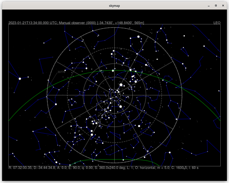
Based on the last TLE posted here I calculated the location at the time of last reception (~13:34Z). FalconSAT-3 was reported at a height of 138km; it could be seen from station “1562 - Pete (VK2PET)” at 5° elevation.
Analysis details
❯ skymap -c ../tabulation-helper/falconsat3/tle5.txt --time 2023-01-21T13:34:00.000 --latitude -34.743 --longitude 148.840 --selevation 565
B defined
L defined
H defined
Use manual site.
FALCONSAT-3 v18
1 30776U          23021.40000000  .00000000  00000-0  21387-2 0    01
2 30776  35.4172 243.6697 0001199  39.3851 303.8126 16.40323102    08

Age: 0.2 d

x:   -2919.0218 km; vx: -5.72327 km/s
y:   +4734.8835 km; vy: -4.94745 km/s
z:   -3395.7554 km; vz: -1.98102 km/s
r:     900.89 km; v:   5.204 km/s
l: 157.49; b: -31.40; h:     138.84 km

R.A.:  12:24:59.92  Decl.:  14:04:18.8
R.A.:  12:23:49.85  Decl.:  14:11:58.3 (J2000)
Azi.: 68.9 Alt.: 5.2

Phase: 60.00
Magnitude: 15.00
Angular velocity: 0.3408 (deg/s)
skymap is a tool from @cgbsat 's sattools . I’m using the spacecruft-branch from here including a small patch (long-option --elevation is defined twice) to be submitted upstream.
1 Like


