A crazy idea with an insane mission. Capture the ISS on a NOAA Image

Backstory on how this came into my mind.
Last week I say on the Science Channel’s “Nasa Unexplained Files” show about how STS-1 was imaged by KH-11 (A spy sat). Today I had the realization while looking at the Perigee and Apogee of NOAA 15 that it is above the ISS’s orbital height. Then this idea started.

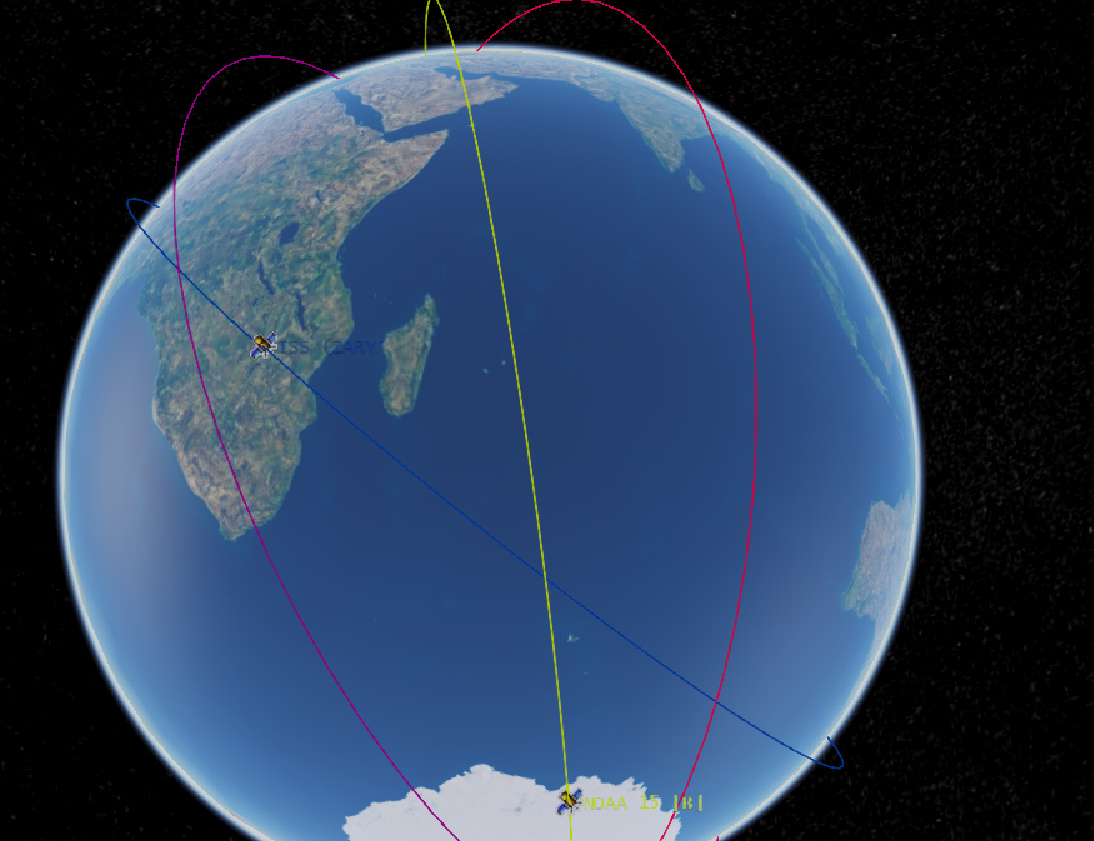
I realize that this will be very hard to do and is probably very well impossible. But there is no harm in trying. I developed a python script to help find these conjunctions I have found that NOAA 15 will offer the best chance of imaging it because of its orbit relative to the ISS. (See Image.)

I will be posting updates to my work at this as I go. Firstly I want to try and find information on how wide of area on earth NOAA 15 images as it moves. Then I will use math to find the area at about the ISS’s orbit that is imaged to know how closely they must line up.

I will also be doing a few tests using just the closest conjunctions I can find to just try it out.

And if anything I will just have some NOAA images of different areas.

8 Likes

Based off some calculations these are the top 10 closest conjunctions in the next 7 days. Only ones that can be heard by the network are listed.

Flat Distance Actually distance Time Stations
304.21476338220003 500.3888389700414 2019-04-23T10:44:00.821565+00:00 [12, 27]
402.3588862506627 565.2111613746698 2019-04-23T10:44:30.821565+00:00 [12, 27]
419.09662858300345 580.4479092900607 2019-04-23T11:32:30.821565+00:00 [15, 23]
152.17667594483217 428.48222245626266 2019-04-24T06:04:30.821565+00:00 [56]
223.34873337279973 457.4566025886324 2019-04-24T06:05:00.821565+00:00 [56]
422.0525026204191 579.8430451329815 2019-04-26T14:29:30.821565+00:00 [2, 12, 27, 41]
500.39109201712296 638.9574666166395 2019-04-26T14:30:00.821565+00:00 [2, 12, 27, 41]
505.73395754682264 645.6319221821941 2019-04-27T09:49:30.821565+00:00 [15, 56]
187.41563331338475 441.9609396198858 2019-04-27T09:50:00.821565+00:00 [15, 56]
235.8734068619278 463.6656344136933 2019-04-27T09:50:30.821565+00:00 [15, 56]

Flat Distance is just taking into consideration the Lat and Lon

Actual Distance takes into consideration the Altitude

Date is the date and time that this conjunction happens.

Stations that are able to listen to this conjunction technically. (It is above the horizon.)

Based off these calculations I believe I will have to wait a few months to do this experiment. Because Ideally I want the flat distance to be well under 100 for the best chances.

Question: do the NOAA satellites transmit images in real time or do they periodically snap a still and then transmit that for a while?

I am 99% sure it’s real time. I will have to look into it tho

Great calculation work @KD9KCK, but there is a slight complication. APT NOAA images are about 4km/pixel resolution (according to here). ISS being aprox 120x90m there is no chance that you can tell if you captured it or not. Even with comparable resolution (let’s say you have 80m resolution), still it would be impossible to spot it since it will be imaged against earth as a background (which is noisy enough).

True. But still interesting to try. Annoyingly the ISS would make up about 4% of the pixel. (That is even considering its 400km higher then the earth.) That is why I said its probably impossible.

Could you rely on lighting conditions to give you a “flash”? If we can see the ISS from the earth on a a good clear evening/morning, couldn’t you use the same principle?

Possibly. Especially if we get it when NOAA is in night IR mode. (I think) I can run some math on that too.

But I think we have the problem of it will have to be during the day when the sun is behind the satellites.

Looking at
https://network.satnogs.org/observations/620805/
and
https://network.satnogs.org/observations/622012/

We can tell that it is in real time. as the images are slightly different but are part of the same pass.

4km per pixel is probably with regards to Earth’s surface. ISS will be 400km closer than Earth so it should be bigger. Not sure by how much.
Given that NOAA-15 is 800km high, perhaps ISS will be twice as big? That would still be too small i guess.

Well the pixel size should be about 2km per pixel. Which is why I would hopefully just count on some odd like streak possibly.

Sort of relevant to this. https://twitter.com/coyotefxl/status/1143556591729426433?s=21

If you can see a falcon launch of a weather sat (granted GEO Stationary and I think some band other then visible light.)

2 Likes