CubeBel-2 corrected TLE
CUBEBEL-2
1 99163U          23178.60752041  .00009659  00000-0  70046-3 0  1232
2 99163  97.6652 229.3207 0010018 222.4731 119.2161 15.02666880   026
CubeBel-2 corrected TLE
CUBEBEL-2
1 99163U 23178.60752041 .00009659 00000-0 70046-3 0 1232
2 99163 97.6652 229.3207 0010018 222.4731 119.2161 15.02666880 026
TLE for METEOR M2-3 from Space-Track
METEOR M2-3
1 57166U 23091A   23178.64273207 -.00000044  00000-0  00000+0 0  9990
2 57166  98.7574 230.4883 0005205  83.9701  67.0780 14.23794768    26
I have received Norby-2 using TinyGS. I noted time stamps and ‘frequency error’, to get some doppler measurement points. The doppler measurements needed to be scaled by -0.90. it is unclear to me why this scaling of 90% is needed. It appears that the LORA chip reports an exaggerated frequency error. The scaling factor was determined by a benchmark fit on GaoFen-7, 54687.
The original TLE was made by @cgbsat and has been updated by @geoscan. The last TLE was propagated and fitted to the data:
Updated TLE:
NORBY-2
1 99128U          23180.36288194  .00000000  00000-0  70046-3 0    07
2 99128  97.6652 231.3257 0017189 261.0540 212.7808 15.03111625    06
# 20230627.82-20230629.36, 13 measurements, 0.145 kHz rms
This shows that with some manual work we can also use doppler curves of LORA satellites.
Corrected TLE for Stratosat TK-1
STRATOSAT TK-1 (RS52S)
1 99151U 23091X   23178.60752041  .00009659  00000-0  70046-3 0  9995
2 99151  97.6652 229.0207 0016018 210.3731 135.2161 15.02166880    25
To @fredy
Please upload this TLE to SatNOGS network
CUBEBEL-2
1 99163U          23178.60752041  .00009659  00000-0  70046-3 0  1232
2 99163  97.6652 229.3207 0010018 222.4731 119.2161 15.02666880   026
Sorry for the delayed update and by the way we definitely need to go away from me being the bottleneck of adding new TLE in DB in the future, anyway let’s discuss it in another topic.
So,
All updated in DB and Network.
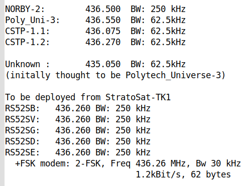
Good day. A quite significant amount of new information about the objects from this deployment with LoRa transmitters has been received by the tinyGS.com administrator (G4lile0 on Telegram).
For anyone scanning 435/436 MHz to identify orbits, or decode the various downlinks from all these ride-along sats, I wanted to share the particulars here so that if any of these LoRa transmitters are seen in SDR waterfalls, the source won’t be a mystery.

… while the downlink details (or even the existence!) of all these satellites was not completely known before this launch, I guess this is a case of ‘better late than never’.
Thanks,
-Scott, K4KDR
Corrected TLE for Stratosat TK-1
STRATOSAT TK-1 (RS52S)
1 99151U          23178.60752041  .00000000  00000-0  70046-3 0    04
2 99151  97.6652 229.6640 0010018 224.3731 120.1981 15.02666880    07
Corrected TLE for UMKA-1
UMKA-1 (RS40S)
1 99136U          23178.60752041  .00000000  00000-0  70046-3 0    07
2 99136  97.6652 229.6640 0010018 224.3731 122.7981 15.02666880    08
TLE for Rassvet satellites:
RASSVET-1-1
1 99125U          23178.60752041  .00009659  00000-0  70046-3 0    04
2 99125  97.6652 229.3207 0010018 222.4731 119.2161 15.02666880    02

RASSVET-1-2
1 99094U          23178.60752041  .00009659  00000-0  70046-3 0    09
2 99094  97.6652 229.3207 0010018 222.4731 119.2161 15.02666880    07

RASSVET-1-3
1 99093U          23178.60752041  .00009659  00000-0  70046-3 0    08
2 99093  97.6652 229.3207 0010018 222.4731 119.2161 15.02666880    06
Update for Norby-2:
TLE:
NORBY-2
1 99128U          23181.72008102  .00000000  00000-0  00000-0 0    07
2 99128  97.6652 232.6832 0000000  58.5838 194.4620 15.03065573    00
# 20230627.82-20230630.50, 18 measurements, 0.157 kHz rms
All latest TLE sets added in DB and Network. Thank you!
There was a technical issue with the Rassvets TLE sets. It was my mistake (copy/paste error) and now is fixed. Thanks to @ENSFNM for noting the issue!
Nanozond-1 (99143), at least for the moment, is decoding as 2k4 USP, not the 4k8 indicated on the SatNogs ‘Transmitters’ page.
Also, the TLE is close but not exactly accurate.
MONITOR-3 TLE based on the below observation.
MONITOR-3
1 99138U          23178.60752041  .00000000  00000-0  70046-3 0    09
2 99138  97.6652 229.2610 0010018 222.4731 130.8185 15.02166880    03
MONITOR-4 TLE based on the below observation.
MONITOR-4
1 99137U          23178.60752041  .00000000  00000-0  70046-3 0    08
2 99137  97.6652 229.3530 0010018 222.4731 130.6702 15.02166880    07
CUBESX-HSE-3 TLE based on the below observation.
CUBESX-HSE-3
1 99141U          23178.60752041  .00000000  00000-0  70046-3 0    03
2 99141  97.6652 229.1544 0010018 222.4731 131.3568 15.02166880    03
NANOZAND-1 TLE based on the below observation.
NANOZAND-1
1 99143U          23178.60752041  .00000000  00000-0  70046-3 0    05
2 99143  97.6652 229.2952 0010018 222.4731 119.1798 15.04548427    01
CUBEBEL-2 TLE based on the below observation.
CUBEBEL-2
1 99163U          23178.60752041  .00000000  00000-0  70046-3 0    07
2 99163  97.6652 228.8709 0010018 222.4731 118.5176 15.02666880    03
And also an ikhnos check.
KUZGTU-1 TLE based on the below observation.
KUZGTU-1
1 99135U          23178.48598380  .00000000  00000-0  50000-4 0    05
2 99135  97.6800 229.4011 0015872 132.1000 249.9650 15.04742672    01
UMKA-1 TLE based on the below observation.
UMKA-1
1 99136U          23178.60752041  .00000000  00000-0  70046-3 0    07
2 99136  97.6652 229.3010 0010018 222.4731 134.0293 15.02166880    02
VIZARD-METEO TLE based on the below observation. (The frequency is 5 kHz lower then registered in the db)
VIZARD-METEO
1 99140U          23178.60752041  .00000000  00000-0  70046-3 0    02
2 99140  97.6652 229.3631 0010018 222.4731 149.4005 15.02166880    07
SVYATOBOR-1 TLE based on the below observation.
SVYATOBOR-1
1 99144U          23178.60752041  .00000000  00000-0  70046-3 0    06
2 99144  97.6652 229.1652 0010018 222.4731 145.4992 15.02166880    03
ACCUBE-01 TLE based on the below observation.
ARCCUBE-01
1 99153U          23178.60752041  .00000000  00000-0  70046-3 0    06
2 99153  97.6652 228.9684 0010018 222.4731 150.3291 15.02166880    02
This is intentionally left blank, sorry for the spam.
Hello!
SSTV signals were received by PE0SAT (https://twitter.com/pe0sat/status/1675158999015075841) in the area of 435.825 – was that from UmKA-1?
If so, could you please let us know what SSTV mode is being used?
Thanks very much!
-Scott, K4KDR